
No. of views : (2897)
Cyclone Nivar formed over the Bay of Bengal!
Posted on: 24/Nov/2020 11:26:15 AM
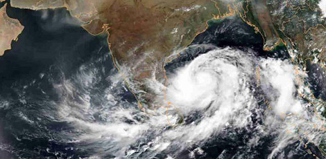

The Chennai Regional Meteorological Centre has informed that the low-pressure formed over the southwest Bay of Bengal has intensified and is transforming into a severe cyclone.
The depression zone, which was stabilized in the upper layers of the atmosphere over the southwest |Bay of Bengal, got intensified yesterday |(Monday, 23rd November) and transformed into a deep depression zone. This is now set to intensify further and transform into a cyclone on Tuesday (today, 24th November). The Chennai Regional Meteorological Centre has informed that during this period, high-speed winds will blow at 110 kmph and intermittently at 120 kmph.
Further, the depression zone is all set to transform into a severe cyclone tonight and is expected to cross the coasts on afternoon, 26th November between Karaikkal and Mamallapuram.
In a notification released in this regard by the Indian Meteorological Department (IMD), it is mentioned: �The depression zone which formed over the southwest Bay of Bengal has now transformed into a cyclone. This is located at a distance of 440 km east/southeast from |Puducherry and at a distance of 470 km from Chennai in the southeast direction.
This depression zone will intensify and transform into a cyclone in the next 12 hours. This depression zone is likely to drift towards the northwest and as per the current situation, is likely to cross the coasts in the afternoon on 25th November between Karaikkal and Mamallapuram near Puducherry.�
Due to the above development, there are prospects for rain in Tamil |Nadu and Puducherry for the next 3 days from 24th November (today, Tuesday) to 26th November (Thursday). There are prospects for very heavy rains in 1 or 2 places in the delta districts and the northern coastal districts. There are prospects for heavy to very heavy rains in the other northern districts in a few places. As regards the Chennai Metro City and its suburbs, there are prospects for heavy to very heavy rains in a few places on Tuesday (Today) and Wednesday (tomorrow).
High-speed winds at 55 mph to 65 kmph are likely to blow in the northern coastal districts on 24th & 25th November. When the cyclone crosses the coast, high-speed winds may blow at 100 kmph to 110 kmph, and at times even at 120 kmph!
There are prospects heavy rains with thunder in a few places in the districts of Thanjavur, Thiruvarur, Nagappattinam, Mayiladuthurai, and Ariyalur today (Tuesday, 24th November). There are prospects for heavy to very heavy rains with thunder in a few places in the districts of Chennai, Thiruvallur, Kanchipuram, Chingleput, Villupuram, Cuddalore, Perambalur, Trichy, and Pudhukkottai and Puducherry.
Post your requirement - We will connect with the right vendor or service provider