Cyclone Sagar forms in Arabian Sea, First of the season
Posted on: 18/May/2018 9:46:20 AM

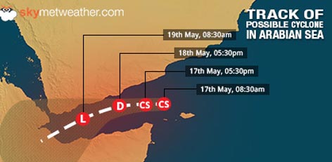
As predicted, the deep depression in Arabian Sea has intensified into a cyclone �Sagar�. It is the first cyclonic storm of the season to develop in the Indian waters.
At present, Sagar is seen over Gulf of Aden near latitude 13.2�N and longitude 48.7�E, around 400 km east�-north-east of Aden in Yemen and 560 km west�-north-west of Socotra Islands.
With system moving in open waters, it may gain more strength and sustain the strength of a tropical storm for at least next 12 hours. Thereafter, as mentioned earlier, the system would gradually start weakening on account of close proximity to the coast.
The cyclonic system is most likely to continue tracking westwards during the next 12 hours and then west-southwestwards in the subsequent 24 hours. Sea conditions would remain rough to very rough.
However, Skymet Weather would like to make it clear that the cyclone has got no bearing off and along the Indian West Coast.
Courtesy: skymetweather.com


