
No. of views : (4266)
After Sagar, Cyclone Mekunu to form in Arabian Sea
Posted on: 21/May/2018 3:29:45 PM
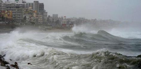
Second low pressure of the season in Arabian Sea is all set to follow the same track of Cyclone Sagar. As predicted by Skymet Weather, the low-pressure area in Southeast Arabian Sea has become more marked and induced a well-marked low pressure area on Monday morning.
It is presently located in Southwest and adjoining Southeast Arabian Sea and centered at 7.9�N and 58.7�E, around 1350 km southeast of Masirah Island, Oman.
Not only this, the system is getting more organized with every passing minute. In fact, cloud configuration and atmospheric conditions are already indicating that system might have already intensified into a depression.
According to weathermen at Skymet Weather, the system is presently travelling in utmost favourable weather conditions. The parameters which are needed for the further intensification of the system are all present, right from low wind shear to long sea travel ahead to conducive sea surface temperatures (SST) to the tune of 31�C.
�it is very rare that we see SST over 31�C in the sea. With such temperatures, we have ample amount of oceanic heat available which would definitely push the system to gain more strength,� said AVM G P Sharma, President- Meteorology and Climate Change, Skymet Weather.
Looking at the curved bands of clouds, we even expect that system would intensify into a cyclonic storm in next 24 hours itself. If this happens, it would be named as �Makunu� and would be the second cyclonic storm of the season to form in Indian seas.
For the next few hours, the system would continue to travel in west direction, thereafter it would move west-northwest direction.
The system is most likely to head towards Oman or Yemen. Although Somalia may escape direct interaction with the system but the peripheral of the system would affect the weather.
However, like Cyclone Sagar, this system has also moved away from the Indian coast and will thus not have any bearing on the weather over the country. But such strong system would continue to govern the wind pattern over the Indian region for the next few days.
The rains over Kerala have already reduced in wake of all the moisture concentrating over the well-marked low-pressure area at present. In fact, more the system would get marked, the more moisture it would take away.
As per weathermen, Kerala should have started witnessing southwesterly winds by now, but due to the presence of this system, northwesterly winds have been blowing. However, the system would not be the cause of concern as it would continue to move far away from the region.
Southwesterly winds would soon make an appearance over Kerala, with a fresh system coming up soon in Arabian Sea. This system would also be responsible for the onset of Southwest Monsoon 2018 over the Indian mainland.
Courtesy: skymetweather.com