
No. of views : (2053)
For the real time flood forecasting system in Chennai, work to start finally
Posted on: 16/Aug/2019 9:59:32 AM
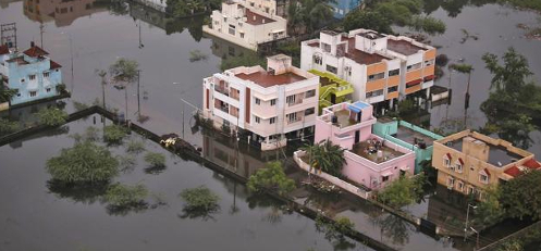

The Chennai city witnessed severe floods in the year 2015 is known. To protect the residents of Chennai city from floods, proper forecasting of the floods is important. The latest news is for developing a real time flood forecasting system for the Chennai city work on the digital mapping of the 5 river basins in Chennai and its suburbs would begin finally.
In the last one year, many strategic installations in Chennai city were assessed. Point is the Ministry of Defence had rejected the proposal for LiDAR mapping by the state government in 40% of the area due to the presence of sensitive installations. For mapping over 5000 sq km of Chennai and its suburbs, state government has been given permission to get assistance from the Survey of India.
The important information is after the 2015 floods proposal to get support from the Survey of India was regarded as major breakthrough in planning, setting up and operating a flood forecasting system for Adyar, Cooum, Kosathalaiyar, Araniar and Kovalam basins plus in setting up of control room at the state emergency operation centre. There were also proposals to set up flood control rooms at GCC, Kancheepuram and Tiruvallur collectorates etc.
According to an official it is clear that for the past 1 year that they have been trying to get the permission from the Ministry of Defence and now there is some clarity. He mentioned about how airborne LiDAR mapping was not permitted for Chennai city and how Survey of India have not supported them. Finally, he hinted that the digital mapping by the Survey of India is likely to be completed before 2020 northeast monsoon season.
Important piece of information is due to the presence of strategic installations in the Chennai city aerial photography and mapping cannot be undertaken for 1903 sq km out of 5000 sq km expanse of Chennai city�s river basins.
It was later mentioned by an official that the entire city as well its suburban area is a restricted zone. He added that important lakes in Kaveripakkam and Poondi reservoir are also present in the restricted area. He concluded that airborne survey would not be allowed within 5 km radius from the runway of the Tambaram airfield.
For flood mitigation plan and for taking preventive steps, data on the digital mapping from Survey of India is very important along with the development of flood forecasting system. On acquiring land for developing flood holding lagoon between Mammallapuram and Palar River, the date would be utilized to make a decision. For making decision on creating new canals to divert water from Cooum and Kosathalaiyar rivers to Palar River in southern parts of Chennai, the government would use the data.
Post your requirement - We will connect with the right vendor or service provider