No Cyclone is expected in coming week
Posted on: 15/Dec/2016 9:45:38 AM
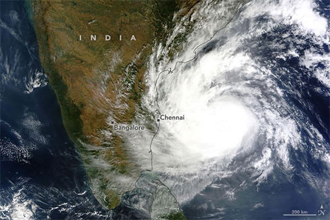
So much rumors spreading about NASA 250 cm rainfall, Elnino cyclone or Maarutha cyclone in whatsapp. Dont believe them. All are crap rumours created by useless people in life. Atleast as a educated people. Lets not forward un-authenticated msgs.
Next System - A trough of low / low pressure area
The next system is probably a pulse moving in via Gulf of Thailand sea into our Bay of Bengal around tomorrow. I want to clarify that no low pressure area is moving into our basin. Its just a pulse coming in and later developing as a trough and as it nears Tamil Nadu coast around 18th December, it may develop into a Low Pressure Area. we need to wait and see which belt gets rainfall. Mostly coastal areas are likely to get moderate rainfall as of now. It does not even have 1% chance to develop into a Cyclonic Storm. So dont worry about another Cyclone as stated in the whatsapp msgs.
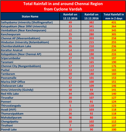
Rainfall from Vardah in Chennai and Andaman a Comparison.
If IMD cut-off at 8.30 am is not there then all the rains which happened in two days happened in less than a day. The rains in Shollinganallur-Guduvancherry-Kancheepuram were more intense than the December 1st, 2015 rains.
Our NEM is still alive and it may extend to atleast one or two weeks into tha January 2017.
Courtesy - Tamil Nadu Weatherman


