Chennai Rain Update - Expect one or two spells today
Posted on: 10/Nov/2017 9:48:54 AM

ECR belt will be the grazing point and other parts of Chennai may get one or two short spell. These are nothing to worry rains but there is chance of sharp spells.
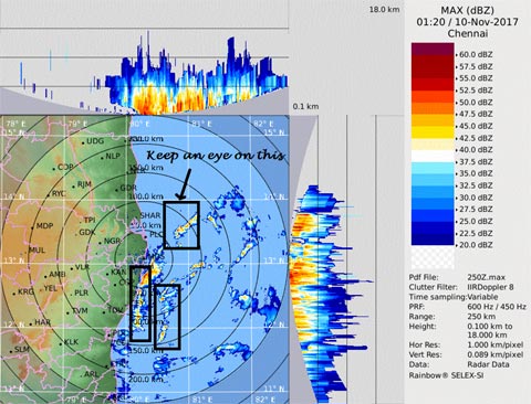
Tricky Radar image
The far away low pressure has pushed one - two bands of clouds to the North TN coast. We can see the band of clouds in Radar in Max z of Radar.
Just because a cloud is nearby, it is not necessary, it will move to city directly; Now just imagine how the water ripples move and at the same time see the wind direction it is in N/NE to South/SW (see the image). So ripple and N to south movement...Hence, the clouds will start to graze ECR first and not the city and slowly spread to OMR areas.
See the two images, i have put up now you interpret yourself whether the big clouds close to us will move into City or graze the city. Then see the area i have marked. Why that one and not the one close to city. Because that one has chance to fall over the city with the ripple and N/NE to S/SW movement. Hope you all understood. Next bands try yourself.
Remember my last low pressure quote - As long as low pressure is there, it may send bands again and again and again. These are just the preliminary bands.
Today and Tomorrow - Delta to rock
Though clouds may threaten us, it will be Cuddalore, Delta to Ramanathapuram belt which will get most of the rains next 2 days. As the wind converges there. And remember it will be windy right from Chennai to Pamban.
Courtesy: Tamil Nadu Weatherman


