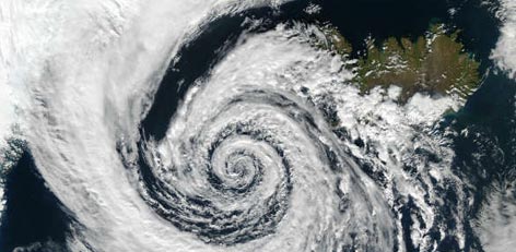
What is a cyclone?
Posted on: 30/Nov/2017 3:11:17 PM

A cyclone is caused by atmospheric disturbances around a low-pressure area and is usually accompanied by violent storms and severe weather conditions. Intense tropical storms are called Hurricanes over the Atlantic Ocean and Typhoons over the Pacific Ocean.
Definition
The word Cyclone is derived from a Greek word cyclos, meaning coiling of snake. Tropical cyclone is a deep low pressure area wherein the central pressure falls 6 to 8 hPa (hectopascal) from the surroundings.
Strong winds spiral around the centre and pick up speeds of 62 kmph or more. These winds rotate counter-clockwise in the Northern Hemisphere and clockwise in the Southern Hemisphere.
Origination and strength of Cyclones
Cyclones originate over the sea and travel about 300 to 500 km a day, drawing heat energy from the ocean waters. A fully matured cyclone releases energy equivalent to few hydrogen bombs. The diameter of a cyclone varies from 150 to 1000 kilometres but their effects dominate thousands of square kilometres of the ocean surface.
Classification of Tropical Cyclones
Cyclones are classified into five different categories on the basis of wind speed, from Category 1 to Category 5. The wind speed varies according to the category of the cyclone, from 60 kilometers an hour to about 220 kmph and above.
Once the winds around the low pressure area reach upto 62 kmph, it is termed as a tropical cyclone and is assigned a name. As and when the wind speed settles between 89 and 118 kmph, it turns into a Severe Cyclonic Storm.
Thereafter, the storm intensifies into a Very Severe Cyclonic Storm when the wind blows at a speed of about 119 to 221 kmph. When the wind speed exceeds 221 kmph, the cyclone is called a Super Cyclonic Storm.
What is the Eye of a Cyclone?
A fully matured cyclone develops a calm centre called Eye with a ring of hurricane winds around it, possessing the following characteristics:
1. Eye forms at the centre of Central Dense Overcast (CDO) region of storm.
2. Diameter of the Eye of a storm is about 10-50 km.
3. Eye is the cloud-free zone, surrounded by thick cloud walls.
4. Eye is surrounded by a 10-15 km thick wall of convective clouds, a zone of maximum wind.
5. Eye is the calm region with practically no rains.
6. Eye is warmer than the surrounding region.
7. Lowest surface pressure is observed at the Eye.
8. Eye is an indicative of very strong winds spiralling around the centre.
9. All cyclonic storms may not develop an Eye.
10. Sometimes, double Eye is also seen, which is indicative of very high intensity.
11. Eye wall is the most dangerous part of the storm.
12. Storm surge, torrential rains and high velocity winds are the associated features of Eye wall.
Courtesy: skymetweather.com


