Latest Weather Update (Tamil Nadu Weatherman )
Posted on: 22/Nov/2018 2:22:32 PM

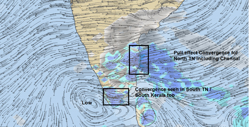
Pull effect rains will give on and off rains for North TN and interiors too while south TN and Kerala will see some rains too
========================
KTC, Coimbatore, Madurai, Tiruvannamalai, Vellore, Tindivanam, Trichy, Salem, Namakkal, Dindigul, Madurai....i can go on...atleast one day rains is possible in each of the districts in Tamil Nadu in the next two days. Rains starts reducing after 23rd in North Tamil Nadu.
On 24th rains are moving down to southern and western Tamil Nadu. Chennai and other places in coast in north TN will get only the isolated morning rains with easterlies in place from 24th. That too here and there.
Nowcast - (coming hours)
--------------
The pull effect bands (clouds) slowly moving in from South / South East. Then the next set of bands are seen Mahabs which should move in. This pattern of rains is going to come on till tomorrow noon with breaks.
See why we should ignore the clouds north of Chennai and see only the one down south of us. The clouds will move predominantly from S-SE to N-NW direction. The radar vvp2 tool comes handy for this.
Chennai rains so far more required. We are left far behind
-------------
Chennai City rain meter - 350 mm rainfall so far from October 1st and we have to cover 500 mm more to get the normal rainfall of 850 mm.
More on and off spell today.
Riskmap
------------
With rains in Chennai today, people can report exact locations of areas that are inundated (areas where water is stagnating) in Chennai on www.riskmap.in. This will be useful to understand where stagnation occurs and how the issue can be addressed.
Courtesy : Tamil Nadu Weatherman


