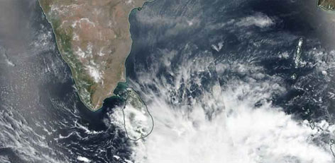
Cyclone Fani intensifies into severe cyclonic storm
Posted on: 30/Apr/2019 2:30:11 PM

The cyclone ‘Fani’, which was located the southeast of Bay of Bengal has now intensified and has transformed into an extremely violent cyclone.
The cyclone, located over the southeast Bay of Bengal and adjacent areas are right now situated at 690 km southeast of Chennai Metro City. It is drifting slowly at a speed of 16 kmph towards the northwest.
As per the information released by IMD (Indian Meteorological Department), the status is as under:
During the evening yesterday (Monday, 29th April) , it intensified further and transformed into a cyclone. After intensifying further, today (Tuesday, 30th April), it has transformed into an extremely violent cyclone and is set to reach the North tamil Nadu-South Andhra coastal area at a distance of 300 km om 1st May (tomorrow, Wednesday) and then drift towards the north and northeast towards Odisha and reach coastal Odisha.
The Chennai meteorological Centre has informed that as the cyclone Fani drifts towards the northwest, there are prospects of mild rain in a few places in Northern Tamil Nadu.
Further, strong winds will blow at speeds of 40 to 50 kmph today (Tuesday, 30th April) in the North Tamil Nadu coastal areas. Sometimes, the speed is likely to be as high s 60 kmph! During today evening, the winds may blow at 50 to 60 kmph and sometimes at 70 kmph.
As the sea at the southwest and the central Bay of Bengal will be turbulent, the weather centre has warned the fishermen not to venture into the sea and those who have gone for deep-sea fishing must return immediately.


