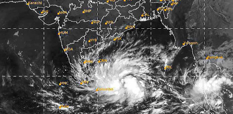
Cyclone Hamoon: Tamil Nadu on Alert for Intense Rain in 6 Districts
Posted on: 26/Oct/2023 10:45:13 AM

There is a high likelihood of heavy rainfall in six districts of Tamil Nadu today as Cyclone Hamoon is set to make landfall in Bangladesh. This weather event originated as a low-pressure area in the Bay of Bengal, gradually intensifying into a storm. The India Meteorological Department named it Hamoon as it gained strength.
The storm`s development was marked by increasing wind speeds, reaching 88 kilometers per hour. It initially moved towards the north and northwest, ultimately heading towards Bangladesh. By Tuesday, it had transformed into a severe storm, causing cyclonic winds and turbulent sea conditions in the Bay of Bengal.
As a precautionary measure, fishermen were advised to refrain from venturing into the Bay of Bengal, and storm warning cage number 2 was set up at various ports in Tamil Nadu, including Chennai, Cuddalore, Nagai, Ennore, Kattupally, Puducherry, Karaikal, Pamban, and Thoothukudi.
Cyclone Hamoon`s path is expected to lead to a landfall between Dingona Island and Chandiwip in Bangladesh today (Wednesday). The states of Odisha and West Bengal are also anticipated to experience heavy rainfall as a result of this storm`s impact. In Tamil Nadu, the districts of Theni, Madurai, Virudhunagar, Kanyakumari, and Tenkasi are likely to see heavy rain, according to the Meteorological Department.


