
Chennai Braces for Heavy Rains as Low Pressure System Approaches
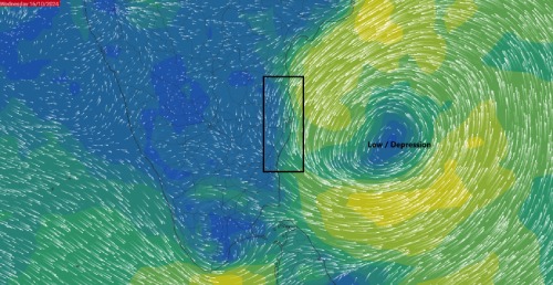

As North Tamil Nadu and South Andhra Pradesh prepare for heavy rainfall, Chennai is expected to experience significant downpours from October 14th to 17th. A low-pressure system is developing near the North Tamil Nadu coast, and the possibility of it stalling near the shoreline indicates that this will not be a brief event. The rains will come with breaks but will also feature some intense spells during the four-day period.
Key Rainfall Areas
The hotspot for these upcoming rains includes the coastal stretch from Pondicherry to Mahabalipuram, Chennai, Pulicat, Nellore, and Kavali. These regions are expected to receive rainfall consistently over the four days, with varying intensities. The Chennai region, along with the rest of the KTCC (Kancheepuram, Tiruvallur, Chennai, and Chengalpattu), is poised for heavy rains, making it one of the most affected areas.
Interior Regions to Receive Heavy Rain Too
The rains won`t be confined to the coastal districts alone. Several northern interior districts, including Vellore, Ranipet, Tirupattur, Villupuram, Tiruvannamalai, Salem, Namakkal, Kallakurichi, Cuddalore, Erode, Dharmapuri, and Krishnagiri, are also likely to experience heavy downpours. Even Bangalore may see at least one day of significant rainfall during this period.
When Will the Rain Start?
The rains are anticipated to begin on Monday, with showers likely from the morning or noon. However, the exact timing is difficult to predict. The most significant rainfall is expected on Tuesday and Wednesday, as the low-pressure system or potential depression moves closer to the coast, bringing dense cloud cover over the KTCC region and likely causing substantial rainfall.
Cyclone Possibility – What to Expect?
While the sea temperature near Chennai and the northern Tamil Nadu coast is above 30°C, creating favorable conditions for the system to intensify, it`s uncertain whether it will develop into a named cyclone. The chances of it becoming a depression are quite high, but even if it strengthens further, it is expected to be a weak cyclone. Winds are not likely to pose a major threat like previous cyclonic events, but heavy rainfall remains the primary concern.
Preparations and Alerts
Officials, bloggers, and weather enthusiasts have all issued alerts regarding the upcoming weather system, ensuring that people stay prepared. While some exaggerated reports may circulate, it is important to stay updated on official advisories. The next update will be provided tomorrow morning between 6:00 and 7:00 AM, hopefully with the rains already making their appearance.
For students preparing for exams, stay focused, as decisions on school holidays will depend on the rainfall situation. Don’t make assumptions about holidays without official confirmation.
Courtesy: Tamil Nadu Weatherman