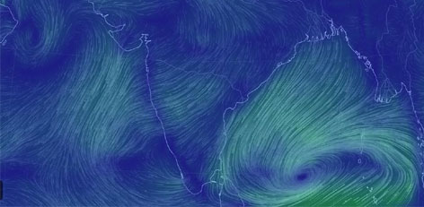
Cyclone Ashobaa near Andaman Islands
Posted on: 05/Nov/2014 11:47:15 AM

After Hudhud, another cyclonic storm - Ashobaa - is now brewing in Bay of Bengal (BoB) and is expected to strike either Odisha or Andhra Pradesh in the second week of this month, sending the India Meteorological Department (IMD) and state government officials on high alert.
The name Ashobaa has been suggested by Sri Lanka, whose turn it is to name the next cyclone.
A low pressure system is likely to form in the sea on Tuesday (November 4) nearly 1,400 to 1,500 km from Visakhapatnam due to the presence of two troughs.
Even as a trough has been persisting over the south Andaman Sea and adjoining Tenasserim coast, with an upper air cyclonic circulation extending up to 3.1 km above mean sea-level, another trough has been hovering over the southwest of Bay of Bengal and adjoining areasof Sri Lanka and Tamil Nadu along with an upper air cyclonic circulation extending up to 2.1 km above mean sea-level.
Under the influence of the troughs, there are chances of circulation of air in the anti-clockwise direction. If the maximum sustained wind speed in the circulation is less than 17 knots or 32 kmph, it can be called a low pressure system and if the speed ranges between 17 to 27 knots, it is called a depression.
Meanwhile the chances of formation of cyclonic storms in November and May are higher in the Bay of Bengal and the current disturbance in the sea was due to the active northeast monsoon.If it is formed, the entire stretch of India`s east coast right from Odisha to Tamil Nadu, including Andhra Pradesh, should remain alert.


