Chennai gets mid-night rains from the clouds moving from sea
Posted on: 09/Sep/2017 10:16:34 AM
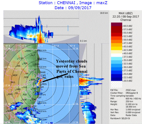
Normally only during our north east monsoon, clouds will move from sea to land or else there should be UAC or low pressure area very close to our coast. There is UAC which is formed now. This is not a low pressure area but a circulation which exists in atmosphere. If the circulation comes down to mean sea level then we call it as a low pressure area. But this one is not going to develop as a low pressure area.
How has this UAC formed - Its due to Equatorial Rossby waves
When ever there is system forming south of equator as a result of ER wave it will spin a counter part circulation in the northern hemisphere or vice versa. You will get and idea. This UAC will not intensify into Low pressure in Bay of Bengal but will bring good rains to the interiors as the winds from sea will clash with the opposing monsoon winds from west from Arabian sea side. So awesome September is going to continue for Tamil Nadu.
Awesome rains in Tamil Nadu. Rainfall ending 8.30 am on 09.09.2017
Delta got smashed with Kumbakonam topping with 162 mm heavy rainfall.
Ponneri in North part of Chennai got smashed with heavy rainfall of 65 mm rainfall from the mid night / early morning spell,
Thoothukudi dt got good rains with upstream areas of Maniyachi getting 62 mm and flash floods happened. No wonder Madurai got flooded yesterday with Tallakulam 108 mm and Madurai South 85 mm. Avinashi in Tiruppur has recorded 89 mm. So awesome season for Tiruppur continues too. Tirunelveli town got 40 mm too....which is rare considering its location. Pamban in Ramanathapuram got smashed with whopping 113 mm rainfall, Most of it happened in morning. Kodaikanal in dindigul samshed too with 104 mm heavy rainfall.
Courtesy: Tamil Nadu Weatherman


