Low pressure in Andaman Sea intensifies into well-marked low, Depression likely in 48 hrs
Posted on: 02/Dec/2017 8:41:01 AM

The fresh low pressure area that had appeared over South Andaman Sea has now further intensified into a well marked low pressure area over south Andaman Sea and adjoining strait of Malacca.
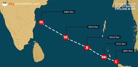
According to Skymet Weather, cloud configuration and atmospheric conditions are indicating towards in further strengthening of the low pressure area. Weather models are showing that the system is very likely to become a Depression during the next 48 hours and move in west-northwest direction.
It is very likely to move towards North Tamil Nadu and South Andhra Pradesh coasts during the next 3�4 days. Let us have a look at the possible track of the system.
In wake of this system, heavy to very heavy rains and thundershowers are likely to lash Andaman and Nicobar Islands during the next 24 hours. Sea will also be rough and fishermen are advised to be cautious before venturing out in the sea.
With lots of seat travel left and favourable sea surface temperatures, chances are there for the system to concentrate into a cyclonic storm in another 3-4 days. If formed, it would be named as Cyclone �Sagar�. However, we have to wait and watch for that.
Unlike Cyclone Ockhi that travelled from Bay of Bengal to Arabian Sea, this system is most likely to cross the Indian coast. As the system would move closer to coast, heavy to very heavy rains are likely over North Tamil Nadu including Chennai and North Coastal Andhra Pradesh between November 5 and November 7.
This is the fourth consecutive low pressure area to form in Bay of Bengal in this Northeast Monsoon.
Courtesy: skymetweather.com


