Know what prevented Cyclone Ockhi from making landfall in Gujarat
Posted on: 07/Dec/2017 10:21:23 AM

The maiden tropical storm of the season, Cyclone Ockhi kept surprising everyone right from the beginning. From the low pressure area in Bay of Bengal, which was never anticipated to be a cyclonic storm to very severe cyclonic storm in Arabian Sea that was supposed to make landfall over Gujarat, kept the meteorologists on toes with its unusual behavior.
As per the weathermen, Ockhi followed a very rare track, wherein it emerged as a low pressure area in Andaman Sea and ended as a depression over Northeast Arabian Sea via Comorin region. It is seen that cyclones developing during this time of the season usually head towards the coast.
One more uncommon thing about the system was that during its long course, Ockhi never made a landfall over the coast. Nonetheless, it skirted the southern parts of Kerala and Tamil Nadu, causing destruction over Thiruvananthapuram and Kanyakumari.
Reasons for the downfall of Cyclone Ockhi
Right from the beginning, Ockhi was travelling in favourable weather conditions. Sea conditions play a vital role in the growth of any weather system. The two major factors that support the sustenance of the system are � a) warm sea surface temperatures (SST) above 26�C and b) low vertical wind shear.
In this case, by the time Ockhi entered into Comorin region, the SSTs were warm to the tune of 30�C and above and vertical wind shear was also low. Hence, the system continued to get more marked until it travelled in southeast Arabian Sea. It had become very severe cyclonic storm over the same location and sustained its strength for almost 24 hours, while travelling north-northeastwards.
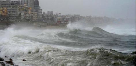
In fact, peripherals of this powerful system had given moderate to heavy rains over the places which were hundreds of kilometers away. For example, Mumbai saw heavy showers to the tune of 82 mm in span of 24 hours from 8:30 am on Monday.
However, as the system entered central parts of Arabian Sea, SSTs had stared reducing drastically. As per the meteorological calculation, if SSTs are below 28�C, chances are there that system would start decaying. Thus, system had then started showing signs of weakening.
Not only this, no matter how strong a system is, proximity to the coast will always stop the system from getting more marked. Let us have a look at the image showing the SSTs along with the track of Cyclone Ockhi:
Initially, Ockhi was expected to cross the coast as a deep depression or a depression. But by the time it reached Northeast Arabian Sea, SSTs were as low as 26�C. Due to this, the system started weakening rapidly and it dissipated long before it could hit the coast of Gujarat.
Arabia Sea is also known for comparatively cool waters.
Courtesy: skymetweather.com