No. of views : (2868)
After Cyclone Sagar, fresh Low pressure area to form in Arabian Sea soon
Posted on: 18/May/2018 10:08:26 AM
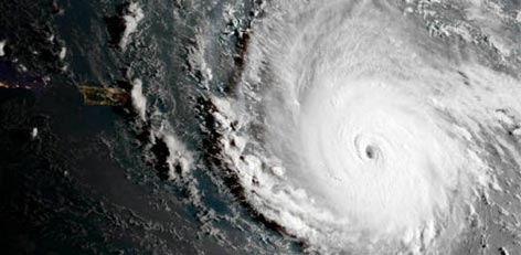
After Cyclone Sagar, Intertropical Convergence Zone (ITCZ) has triggered another weather system in the Indian waters. A cyclonic circulation had originated in the Comorin area during the last 48 hours. Moving westwards, the circulation is now seen over Southeast Arabian Sea and neighborhood areas.
According to Skymet Weather, the system is moving onto favouring weather conditions, due to which the circulation is most likely to intensify into a low pressure area very soon.
With the long sea travel ahead, the system has potential to gain even more strength. In fact, this system may follow the same track as Cyclone Sagar. We expect this system to churn out into a deep depression but whether it would become a tropical storm or not is yet to ascertained.
For the next three days, it is likely to move west-west direction, thereafter moving into west-northwest direction towards Somalia.
The cyclonic circulation has also revived pre-Monsoon rains in India, which has been giving good rains over parts of Kerala since last 2-3 days. We expect that the system would continue to give more rains over the state.
However, as the system gets more marked, it would take away all the moisture from the nearby areas. Thus, rains over Kerala would reduce gradually. Thereafter, the system would move away from Indian coast and would not have impact over its weather.
Courtesy: skymetweather.com