Cyclone Gaja update (Tamil Nadu Weatherman)
Posted on: 12/Nov/2018 3:08:09 PM

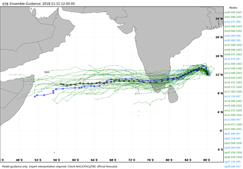
Cyclone Gaja to take SW dip early and take super speed steering under the control of Indian Ridge and make landfall as a Cyclone between Cuddalore and Vedaranayam of morning to Noon of 15th November. Chennai to see rains a day earlier from 14th November itself.
======================
Steering change is happening right now. It has hardly moved in last 4 hours. Once Steering Change is complete, it is expected to make an early dip, landfall is expected to be earlier on 15th morning - Noon in delta belt. Gaja will now give rains to South Tamil Nadu interiors instead of Northern Interiors. Northern interiors too will get rains as Cyclone moves inland but not as the quantum of central / southern interior districts
Chennai - Good rains can be expected on 14th/15th
------------
Chennai meanwhile is expected to get rains a day early from 14th november itself. Entire North TN coast will get rains from Gaja 14th/15th. Though chennai might be windy, we will be very far away from the influence of Cyclone winds.But the good news is Chennai will get pull effect rains on 15th and 16th too. So the rainfall expected is more now compared to previous days forecast. I will be happy with 150 mm rainfall from 2-3 days from Gaja in Chennai. Remember we have just got 200 mm from October 1st in Chennai.
Extreme rains
-------------
Extreme rains are expected in the landfall area of Delta belt and also the Southern Interior districts and the ghats in the south,
Winds - Gaja is not going to be a strong Cyclone like Vardah or Thane
--------------
Gaja is expected to intensify in next two days and bu as said in previous post this will not be strong cyclone with the W-SW dip, we can expect winds to clock 60-80 km/hr and at times gust touching 90-100 km.hr. This will much lesser intensity than Cyclone Vardah in Chennai clocked 120 km.hr winds with gusts of 140km.hr. While Thane in Cuddalore clocked 140 km/hr and gust reached 160 km/hr.
Good News
----------------
Gaja activates monsoon after going into Arabian sea Interiors will see pull effect rains on 16th. But then a next low is expected to form around 19/20th November in Bay of Bengal within few days of Gaja.
So great days ahead for NEM....Bay is going to be super active in coming days. With low expected come one after another and we need to see where it will move.
Fishermen shall not venture into Bay of Bengal till 16th November as it will be very rough.
Further Changes
-----------------------
With 3 days to go, we can expect more adjustments before firming up the exact landfall and intensity.
Courtesy - Tamil Nadu Weatherman


